Geographically Weighted Regression Analysis of Wildfires in British Columbia
Participants:
Joshua Green
Affiliation:
Geography Department, University of British Columbia
Advisors:
Professor Brian Klinkenberg
Participants:
Joshua Green
Affiliation:
Geography Department, University of British Columbia
Advisors:
Professor Brian Klinkenberg
Abstract:
In recent decades the Pacific North West has repeatedly experienced all-time high wildfire events. In Canada, the most recent two decades have had significant increases in the annual burned area (Podur et al., 2002; Gillett et al., 2004). British Columbia declared states of emergency in both 2017 and 2018 during two record-setting years. 2017 was one of the worst wildfire seasons in provincial history, with over 1.2 million hectares of land burned, and approximately 65,000 people evacuated. This was then surpassed in the 2018 fire season during which over 1.35 million hectares of land burned. In both years weather was reported as the key driver of fire activity, with historically high temperatures and severe lightning storms throughout the province. Climate change driven by human activity is expected to result in more frequent and higher-intensity fires, with severe environmental and economic consequences (Bush and Lemmen, 2019). Research by the Canadian Centre for Climate Modelling and Analysis found that dry weather directly caused by greenhouse gas emissions made BC’s fire risk 2-4 times greater in 2017 (Kirchmeier-Young et al., 2019).
Reducing wildfire risk and enhancing community resilience to disaster events requires adaptive management practices and science-informed decision-making. It is critical that we understand the factors influencing wildfire events in order to develop efficient strategies for fire management and mitigation.
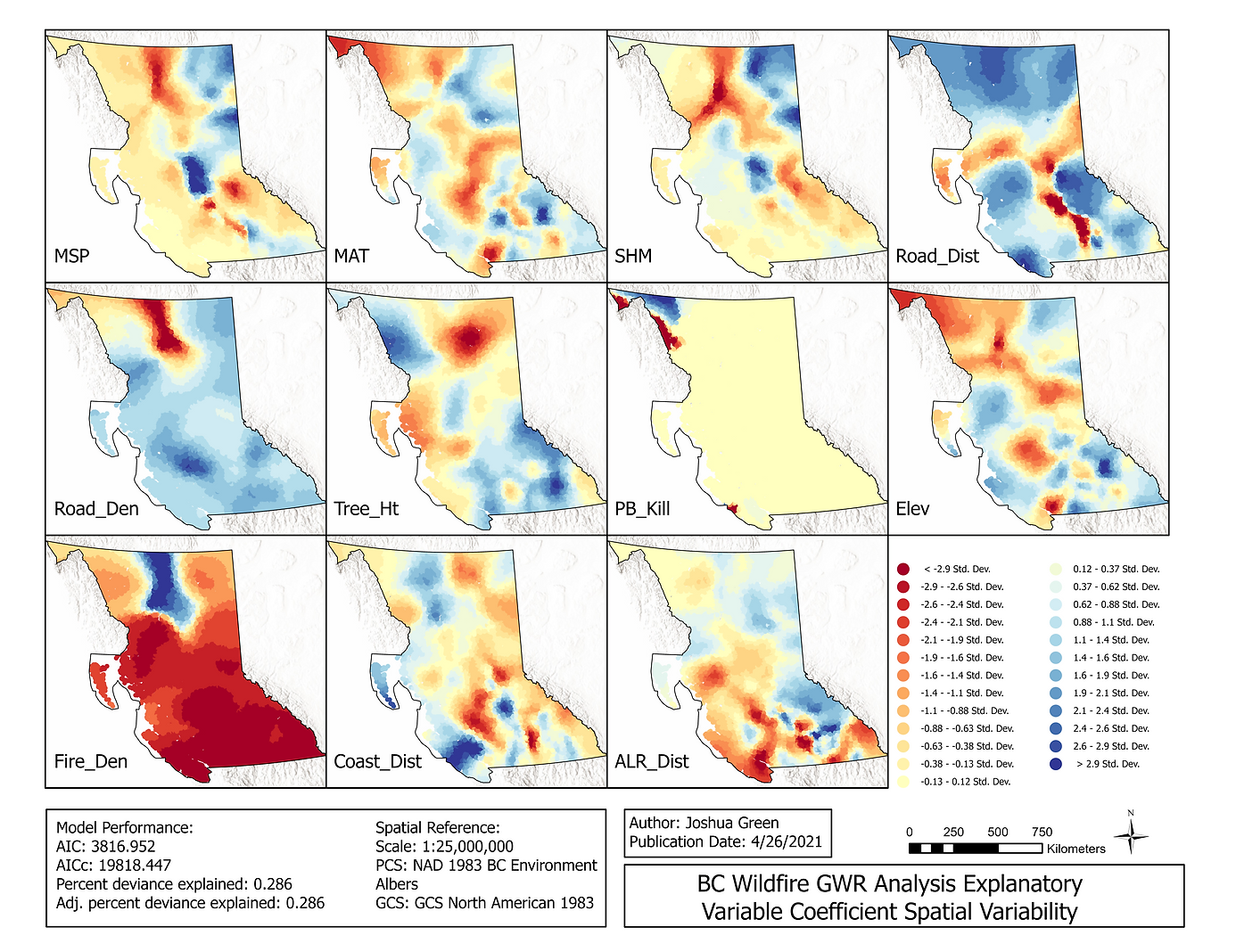
This study used a combination of Ordinary Least Squared (OLS) Linear Regression and Geographically Weighted Regression (GWR) analysis to advance understanding of the spatial relationships of factors driving wildfire events and the spatial distribution of fires in British Columbia.
The objectives of this analysis were to 1) assess the spatial variability of wildfires in British Columbia, 2) identify the primary social, economic, ecological, and climatic variables that influence wildfire patterns, 3) analyze the predictive capability of explanatory variables on the long-term distribution of fire events, and 4) explore the variability in the relationships of those variables at local and regional scales.
Project Results: